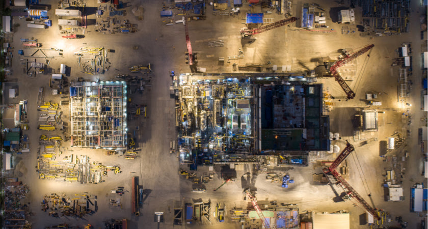
The design model says the slab is at RL 12.400. The as-built cloud says 12.490, in a stripe that follows yesterday's pour. Nobody on site is surprised. The argument starts when the BIM is treated as the site, and the capture is treated as a pretty picture.
DJI's construction note puts drones in BIM for a boring reason: the software is only as current as the last measured surface you fed it. Photogrammetry or LiDAR from the air is how you get that surface without closing the pad. The overlay (design against capture) is the product. A living IoT graph of every asset is a different contract. Most Australian tenders that say digital twin mean the first thing: a georeferenced 3D you can measure, and fly or walk again on a known grid.
What BIM is asking for
AS ISO 19650.1 is the Australian adoption of the ISO 19650 information-management series. It does not care which sensor you used. It cares that the information requirements are written down: what objects, at what level of information, in which coordinate system, for whom, at which information exchange. The drone capture is one of those exchanges. It is not the BIM. Someone still authors walls, slabs, services and the asset data in the authoring tool the office already licences.
DJI describes three moments that match how a site actually runs.
Before. Topography and the existing surface go into the design model so the first earthworks quantities are not a guess from a contour that is four years old.
During. Repeat the same mission. Overlay this week's surface on the design. Stockpiles, pad levels, crane locations, the pour that moved. The value is the difference, not a new pretty mesh.
After. Facades, roofs and the as-built envelope for facilities. The interiors, plant rooms and the underside of anything the aircraft never saw are still a second capture.

If the information requirement was "LOD 300 architectural BIM from a single grid flight", the requirement is wrong. A flight gives you a surface and a cloud. The modeller snaps to it. That is scan-to-BIM, and it has a floor. It is also why a colourised cloud is not a substitute for the object tree.
DJI's BIM article lists roles that are real and roles that get inflated. Stockpile volumes from a repeat surface: real, if the grid and the ground classification are the same both days. Prefabricated embeds located from a flyover: possible on an open slab with LiDAR or a tight GSD, and still a check against the set-out, not a replacement for it. Progress photos from a grid: useful for the Friday email, and not a twin. The overlay is the thing that earns the word. Design object against measured surface, on one datum, with a date.
Photogrammetry or LiDAR, on purpose
Photogrammetry builds 3D from overlapping photographs. It is cheap to fly, colour is native, and on open, well-textured ground it is the right ortho. It fails on wires, on glass, in the dark, and under canopy: you get a DSM of the leaves, not a DTM of the dirt.
LiDAR times a laser pulse. With an IMU and a GNSS trajectory it writes a point in space whether the surface had texture or not. DJI's LiDAR note is still the practical split: thin structure and ground under vegetation are why you pay for the payload. A transmission tower and its conductors are the textbook case. Photogrammetry will reconstruct the tower body and invent or omit the wires. The cloud from a LiDAR pass has the conductors if the pulse rate, returns and flying height were set for them.

DJI's 2022 hardware examples were an earlier airframe and L1, quoted at 5 centimetres vertical and 10 centimetres horizontal from 50 metres in that article. Current lab figures live on the payload page, with their altitude, scan mode and base stated. On an Australian site the number that matters is the check-shot RMSE on the surfaces the engineer will defend, after PPK or NTRIP, in GDA2020 and AHD. Brochure centimetres are a planning ceiling.
You can fly both. Colour from the camera, geometry from the laser, same trajectory. That is a loadout decision, not a philosophy.
One datum, or the overlay is theatre
The design BIM is on a project grid. The aircraft is on GNSS. If those are not tied, the overlay is a slide. Write GDA2020, the MGA zone and the height system on the flight card. Use the same AUSCORS mount or the same local base as last month. Process in the same output coordinate system in Terra (the repeated-survey problem). Then the 90 millimetre slab is a 90 millimetre slab, not a zone mistake.
Stockpile volumes follow the same rule. A volume is a surface difference. If visit two sits 80 millimetres high because the geoid changed, the cubic metres are fiction. Repeat the mission template: height, overlap, trigger, scan mode. Cadence is a documented roster, not "whenever someone is on site".
A weekly photo set from 120 metres with a different heading each time is not that roster. The reconstruction will still finish. The difference model will mostly be method: overlap, GSD, time of day, standing water, machinery that moved. The reviewer who has been burned once will ask for the mission template before they ask for the cubic metres. Give them the template.
What the aircraft will not see
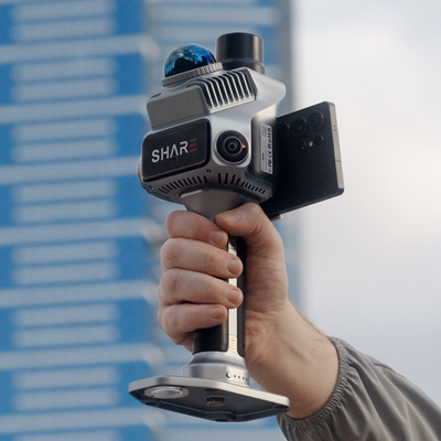
Roofs, open pads, corridors of dirt: fly them. Plant rooms, stair cores, the inside face of a parapet, under-canopy stems, the underside of a deck: those are a handheld walk on the same grid, or they are missing. RTK on the aircraft does not see through steel. DJI's BIM piece talks about "LiDAR drones gathering information about the insides of structures". That is a payload on an airframe that can legally and physically enter the space. On a typical Australian commercial pad it is not how the plant room gets into the federated model.
Registration is a check, not a faith position. Overlay a kerb, a tank, a roof edge. If the walk drifted in a feature-poor corridor, fix the traverse before you argue with the aerial block. Two datasets, one frame, a join you looked at.
Failure modes
Calling the mesh a BIM. The mesh has no IFC types, no asset IDs and no status. It is geometry.
Flying once and selling a twin. Visit-one LAS with no repeat plan is a survey deliverable. Call it that.
Wrong height system. Ellipsoid against AHD is metres, not millimetres.
LiDAR at a height and pulse rate that never reached the ground, then a DTM issued from first-return canopy.
A second visit with a different GSD, overlap or output CS, then a change-detection report that is mostly method.
We have not authored a federated BIM from a cloud as a service, and we do not run a client's CMMS. If the brief is alerts in a maintenance system they already own, that is integration, scoped and quoted. The kit as sold is capture, a processing path and a file the modeller can open. We have not published a progress-overlay study on an Australian pad against a design IFC, with check shots. The mechanism above is the one we set up. The centimetres on your slab are still yours to check.
What the reviewer should open
Information requirements that name the objects a cloud can actually support. Datum and geoid identical to the design file. Check shots on hard, open surfaces. Join check where air meets ground. Wires and canopy called as LiDAR (or explicitly out of scope). Repeat mission saved. The overlay, not only the pretty reconstruction. A sentence that says what will be captured next time, and who processes it. If the information requirement asked for BIM objects the cloud cannot see, send the requirement back before you fly.
Where we stand
We supply the aircraft and the payload, including L3 on Matrice 400 when the brief is LiDAR, and a C1 Pro walk for the volume the rotor cannot see. We set the datum and the processing path. We do not produce the BIM objects and we have not published a progress-overlay study on an Australian pad.
If you already have a design model and a capture that will not sit on it, send the overlay (or the two CS definitions). We will tell you whether it is a datum, a missing interior or a method that was never going to see the thing you are arguing about.
FAQ
Is a point cloud a digital twin?
Not by itself. In this workflow a twin is a georeferenced model you can refresh and overlay on the design. Visit-one LAS with no repeat plan is a survey.
Does the drone write the BIM?
No. It writes a measured surface and a cloud. Objects are still authored in the BIM tool against that geometry.
Can we skip the interior capture if the aircraft has RTK?
Only if the information requirement is roofs and open ground. RTK does not see through a slab.